Leica Digicat: Εντοπισμός Υπόγειων Δικτύων για την προστασία εργατών κατά την εκσκαφή
1,400.00€
210 2519273
info@mobact.gr
Πατήστε εδώ

Leica Digicat 750i xf SMARTREADY locators delivers a true digital platform with additional low tracing frequencies making locating and tracing buried utilities over long distances an easy and efficient task. Pioneering, fully integrated GPS and data logging, it delivers increased visibility-of-use, on where, when and how the cable locator has been used.
An easy-to-use cable avoidance tool with fully-integrated GPS technology, data logging and Bluetooth® to trace utilities over long distances!

Improved mobile flexibility allows the Digicat SMARTREADY locator to work with 94% of mobile devices, reducing restriction of use and strengthened fleet utilisation.
Increased confidence & extra visibility of locating results
Improved accuracy & application scope
The Leica Digicat 750i xf SMARTREADY cable locator features:

Uncovering safer, faster, more
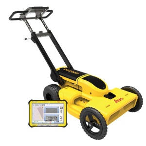
There’s a lot going on underground that you need to know about before you ever start to dig. The Leica DS2000 Utility Detection Radar finds all potential threats, including non-conductive pipes and fibre optics, increasing safety by lowering the risk of accidently hitting underground assets.
Increase safety, speed up work and lower asset management costs with the ability to prevent hazardous outages and collect more information. The DS2000 betters your business by making it safer, faster and more efficient.
Key benefits
Detection and underground mapping solution
Combined with the powerful and rugged Leica CT2000 field tablet, the GG04 or the GPS60 smart antenna, and the DIGICAT intelligent cable locators and DIGITEX transmitters, the DS2000 is part of the complete Leica Geosystems detection and underground mapping solution that will enhance your business by making it faster and more efficient. With DX Office Vision post processing software, convert radar data to CAD file in an uncomplicated way.

1,600.00€ Η αρχική τιμή ήταν: 1,600.00€.1,500.00€Η τρέχουσα τιμή είναι: 1,500.00€.
3,800.00€ Η αρχική τιμή ήταν: 3,800.00€.3,590.00€Η τρέχουσα τιμή είναι: 3,590.00€.

ή πληροφορίες και θα σας απαντήσουμε το συντομότερο δυνατόν.

ή πληροφορίες και θα σας απαντήσουμε το συντομότερο δυνατόν.